genealogy
Index
Part 1
Part 2
Part 3
Part 4
Part 5
Part 6
Part 7
German
Audiofile
on this part
(German)
Mapping below ground
An inscription of 1912. Somebody perpetuated himself at the end of a side passage. An interesting discovery for Stan and Rick of the Cave Research Foundation. The inscription is photographed, its position is carefully noted and recorded in the inscriptions data base.
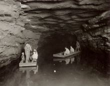
In the 60's the members of the Cave Research Foundation started research in Mammoth Cave and the many other caves in the national park. Most of them are amateurs, as far as speleology is concerned. Stan is a physician, Rick is a biologist. They share a great enthusiasm for caves and for the fascination of the dark unknown.
Every year the group organizes expeditions in order to explore new passages. Often the researchers stay underground for several days because the areas to be explored are situated many hours away from the next entrance. Only well-trained and safety-conscious people may join the team. Adrenaline junkies looking for risks are of no use. What if deep inside earth an accident would occur!
Each discovery is mapped immediately. That´s the only way to keep track of the tangle of underground passages. And each year new galleries are added - an end is not in sight. Until today, the group has mapped and entered into computer programs more than 350 miles of cave passages. Thus, Mammoth Cave is by far the longest cave in the world.
As long as 150 years ago, the owners tried to attract visitors with fantastic statements about enormous dimensions of the cave. Over 100 miles length were claimed by an advertisement of the 19th century. The figure was mere speculation, because exact data concerning the extents of the labyrinth did not exist. Different rough sketch plans circulated, but there was no exact cartography of the cave. The owners did not want it. Each attempt to map the cave was stopped by them. And not without reason, as a traveler already experienced 150 years ago:
" "Sir! Is there no map available of your infernal kingdom?" - "Map?" repeated Mr. Proctor, who in wintertimes is not only the owner of the hotel and the cave but also if necessary waiter and guide. "No, Sir! There is no map. The cave was never surveyed. The owners do never allow a survey of the interior of the famous Mammoth Cave." And he left the room.
The man had a sharp nose. Most Kentuckians have one. He smelled that there was an enemy. After some minutes his son came in. I ordered one more drink and let me show the Kentucky rifle (on the wall). Then I asked in an unconcerned way why the cave was not mapped. The boy was less polite than his father: "Dam me! Anyone should try this!" and he knocked the butt-end of his rifle on the roaring floor.
"You know, the cave is damned big - we bought 2000 acres around the entrance, but - dam me" - that´s a complete waste! One branch for sure reaches as far as Cave City, another near Glasgow. On some places the cave is deep under ground. On others it is close to the surface. If anyone in Cave City knew its course he would dig a new entrance and then - good night, Cave Hotel! - it would be our ruin!"
The young man did probably not suspect how right he was. In 1921 a mining engineer named George Morrison succeedes in opening, from the adjoining property, another access to the cave, called the "New Entrance". Morrison knew how to make money from his discovery: He built a hotel and, by means of a large publicity campaign and enormous sign posts, he directed the visitors into his part of the cave. And as his "New Entrance Hotel" was closer to the main street than the old lodging house, there business went downhill, while Morrison's enterprise flourished. A violent controversy broke out, conducted verbally as well as by force of arms - a story which eventually entered history books as the "Kentucky Cave War". Only the establishment of the National Park in 1941 terminated the battle.
When Max Kaemper started his research in Mammoth Cave in 1908 the cave owners were aware that the cave probably extended far under the adjoining properties. And therefore they forbade categorically each mapping attempt to anybody because an exact cave map would be an extremely explosive document. On the other hand: Without an exact measurement the legal risks in any controversy with the neighbours could not be estimated.
In this dilemma the young German Max Kaemper with his boundless enthusiasm for the cave came in handy: The owners could be quite sure that he would not talk a lot about the results of his measurements. He would go home - and the owners could carefully hide his map.
After some hesitation the owners of cave gave green light for the mapping. For free food and lodging in the cave hotel Max should draw a cave map.
The owners had an obvious motive for this
agreement. But what about Max, what were his motives? What caused him
to start his research; how did he get the strange idea to travel in
February 1908 to that uncomfortable, cold town of
Cave City? His note book does not give any explanation and his family
is just as puzzled as we are.
Previous
Start
Next